Cooler Start to June Despite Record-Breaking May
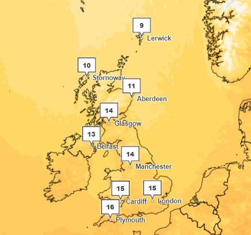
Following the UK’s warmest May on record, many residents eagerly anticipated a hot June, preparing outdoor barbecues and updating their summer wardrobes. Contrary to these expectations, the first ten days of June have been surprisingly cooler, with temperatures averaging two degrees lower than anticipated in southern England. This trend is expected to persist in the short term, with even the possibility of overnight frost in some areas on Tuesday night.
The Role of the Atlantic Jet Stream
Dr. Robert Thompson, a meteorologist from the University of Reading, attributes the cooler temperatures to the behavior of the Atlantic jet stream. This fast-flowing air current, which moves from west to east, has been situated further south than usual for this time of year. Consequently, it has been steering cold air from Greenland and Iceland into the UK. Dr. Thompson explains that the jet stream “wriggles around,” directing winds from various regions and affecting local weather patterns. Despite the cooler start to June, Dr. Thompson reassures that this is not entirely unusual and that warmer weather is likely to return, potentially resulting in an above-average summer temperature.
Impact of the Jet Stream on Current Weather Patterns
The unusual positioning of the jet stream has led to cooler winds from the Arctic, lowering temperatures across the UK. As the jet stream gradually shifts northwards, it is expected to bring higher pressure and warmer weather across England and Wales. Dr. Thompson acknowledges that while the current weather may not align with typical June expectations, the recent trend of rising temperatures due to global warming has skewed public perception. He highlights that only three out of the past twelve months have been colder than average in the UK, suggesting that the return to warmer conditions is imminent.
Predictions for the Remainder of June and Summer Outlook
According to Dr. Thompson, temperatures are expected to normalize towards the end of the weekend, with the likelihood of above-average heat this summer. He also anticipates periods of drought and thunderstorms, phenomena often associated with warmer conditions. A Met Office spokesperson corroborates this outlook, noting that June temperatures across the UK are currently three to four degrees below average. The forecast for the upcoming week remains unsettled, but a return to warmer weather is expected shortly thereafter.
Day-to-Day Weather Forecast
On Tuesday, the Met Office predicts a bright day with sunny intervals for many parts of the UK. However, rain is expected to affect northern, central, and eastern England in the afternoon, accompanied by a cool northerly breeze that will keep temperatures below 18 degrees Celsius.
Conclusion
While the cooler start to June may be disappointing for those hoping for an early summer heatwave, the overall outlook remains optimistic. The influence of the Atlantic jet stream is a temporary factor, and as it adjusts its position, the UK can expect a return to warmer, more typical summer weather. With the potential for above-average temperatures, residents should be prepared for both pleasant summer days and the possibility of extreme weather events such as droughts and thunderstorms. As global warming continues to influence weather patterns, understanding these dynamics becomes increasingly important for accurate weather predictions and preparations.


